
Shoreline Erosion on Lake Martin: Signs, Causes & Fixes
Shoreline erosion on Lake Martin is usually slow enough to miss. Wakes and wind waves nibble at the waterline all summer, the lawn's edge retreats a few inches at a time, and then the drawdown exposes a bank with roots dangling out of it. This page covers what wears a Lake Martin bank down, what to look for at summer pool and at the 484-foot winter level, and the fixes the rules allow, from plantings and fiber logs to riprap and seawalls, along with the limits that apply to each.
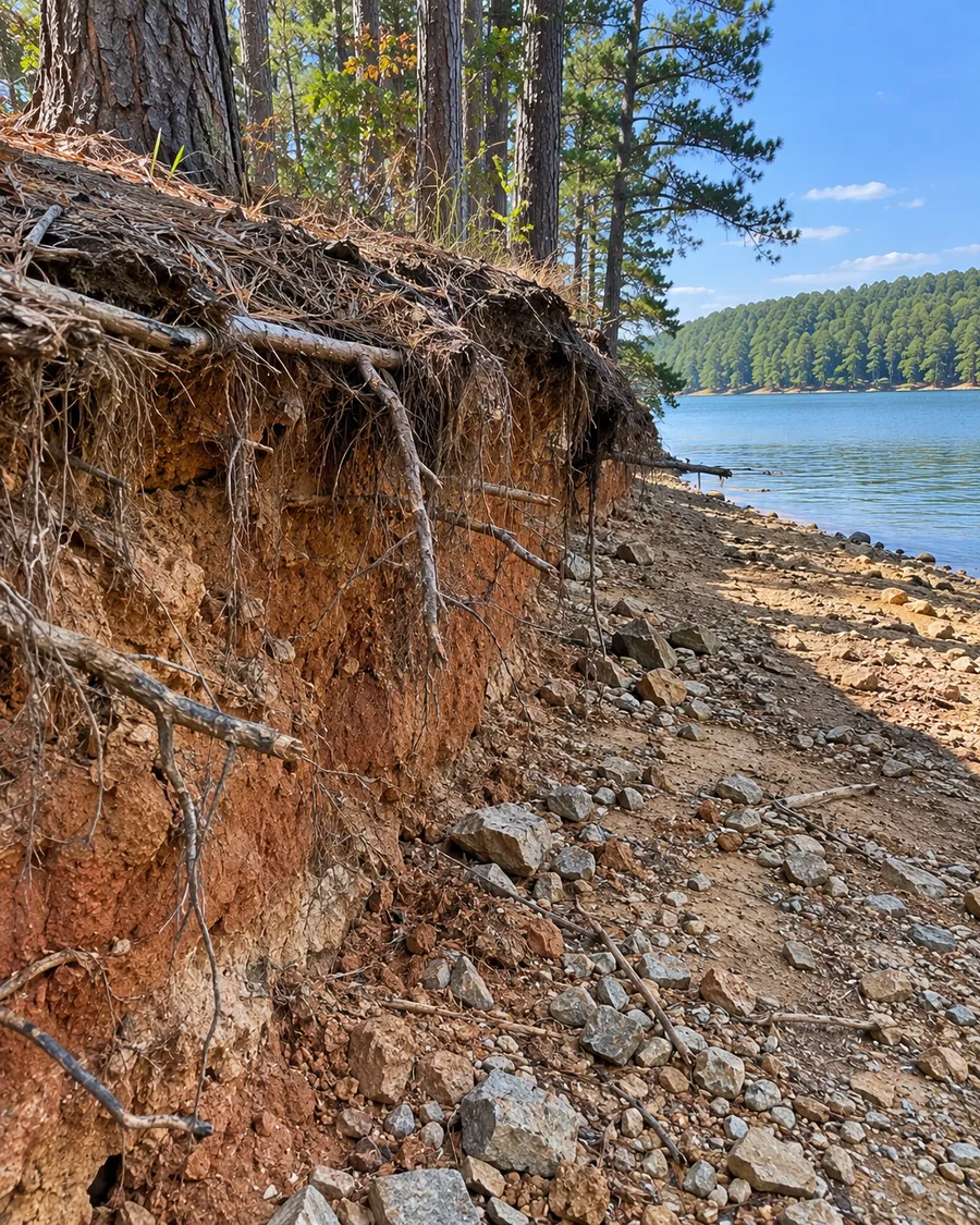
What wears a Lake Martin bank down
A lake bank loses ground where moving water meets bare soil. On Lake Martin a few forces work on the same strip of shoreline:
- Waves and wakes. Wind-driven waves and boat wakes hit the bank at the waterline and pull loosened soil back into the lake. Alabama Power puts the lake at 41,150 acres and 31 miles long, so some shorelines face a long stretch of open water and others sit in sheltered coves.
- A waterline that moves. The lake sits near 491 feet in summer and is lowered to 484 feet by late November. Waves don't work on one fixed line; they work across a band about seven feet tall over the course of the year.
- Runoff from above. Water from roofs, driveways and lawns that runs over the edge of the bank cuts gullies from the top down, which no amount of rock at the waterline will fix.
- Lost cover. Grass mowed to the edge, cleared brush and foot traffic leave soil with nothing holding it.
Signs to look for
Walk your shoreline twice a year, once at summer pool and once while the lake is down. Winter is when most of the evidence is visible.
At summer pool
- A short vertical "cliff" of bare soil at the waterline.
- Muddy water along your bank after wakes, when the neighbors' water is clear.
- Grass or sod hanging over the edge with nothing under it.
- Stairs, paths or a dock walkway that now end in a drop.
At winter level
- A notch cut into the bank where the summer waterline sits.
- Tree roots exposed and hanging in the air.
- Old riprap that has slid down the slope or out onto the lakebed.
- Soil washing out from behind or under a seawall.
The fixes the rules allow
Alabama Power's Lake Martin guidelines state its preference: "Rip-rap and natural bank stabilization are the preferred methods of erosion control; however, potential use of seawalls will be evaluated on a case-by-case basis." The Corps of Engineers' PGP-05 covers the same range of methods. From the gentlest to the hardest:
Natural and bioengineered stabilization
Plants, and plants combined with materials like fiber logs. The PGP authorizes "Stabilization of eroding shoreline utilizing appropriate bioengineering techniques," including "soft" engineering with "fiber logs, aquatic or semi-aquatic vegetation," and says projects using vegetative and bioengineering practices "are not subject to length restrictions." These suit low banks with modest wave exposure. Ask Alabama Power what it wants to see in the application, since "natural bank stabilization" sits with riprap at the top of its list.
Riprap
Sloped loose rock along the waterline, and one of Alabama Power's two preferred methods. The PGP caps the bedding laid under the high-water line at an average of a cubic yard for each foot of bank, puts no cap on rock above that line, and says fabric "shall be considered and may be required." The riprap guide covers it in full.
Seawalls
A vertical wall needs Alabama Power's lot-by-lot approval. It has to hug the current bank line, it may need rock along its foot, and under the PGP a new one can't stand more than 36 inches lakeward of full pool. See seawalls.
Limits that apply to every fix
- A permit first. The guidelines cover "sea walls and rip rap for bank stabilization, and re-grading," and other ground-disturbing activity on or near the shoreline. Reshaping the bank counts.
- No reclaiming lost ground. The PGP "may not be used to regain land lost to erosion, or otherwise accreted land," and Alabama Power allows backfill "only to the contour of the natural slope of the property."
- Clean fill only. "No debris or foreign materials may be used as backfill," and whatever fill is used, Alabama Power has to sign off on where it comes from and what it is.
- No wetland fill. "No wetlands may be filled."
- Nothing perpendicular to shore. Groins and jetties aren't authorized under the PGP.
- Sediment controls while the bank is open. "Appropriate soil erosion and sediment controls must be used and maintained in effective operating condition."
- Sensitive Resource Areas. On a lot identified as one, nothing happens until Alabama Power authorizes it in writing.
What you can do without a contractor
Not everything is construction. Some steps help and stay away from the lakebed:
- Stop mowing right to the edge and let a strip of taller growth hold the top of the bank.
- Send roof and driveway water away from the bank edge, so it isn't cutting gullies from above.
- Keep foot traffic to one path to the water.
- Photograph the bank from the same spots each summer and winter, so you can see how fast it's moving.
Anything that reshapes the bank, adds fill or puts material in the lakebed is a permit question. Outside of painting and pressure washing, Alabama Power treats work in the lakebed, its flood easement or its control strip as something that could need a permit, and that can include planting on a control-strip lot. Call before you dig.
Erosion questions
Can I fill in the ground the lake took and put riprap on the new edge?
No. The Corps PGP can't be used "to regain land lost to erosion," and Alabama Power limits backfill to the natural slope of the property. Stabilization protects the bank where it is now.
Is planting enough on Lake Martin?
Sometimes, on low banks with little wave exposure. Alabama Power lists natural stabilization alongside riprap as preferred. On a tall bank facing open water, a contractor may recommend rock.
When is the best time to look at erosion?
During the winter drawdown, when the lake is near 484 feet and the lower bank is exposed. See the drawdown page.
Having a bank looked at
Call (256) 667-6569 or send a request describing the bank and roughly where your lot sits on the lake. One independent local contractor will walk the bank with you, say which fix suits it, and send a written price. The referral costs you nothing.
Related pages
Sources
- Alabama Power, residential shoreline permitting guidelines for Lakes Martin, Yates and Thurlow (revised July 11, 2025)
- U.S. Army Corps of Engineers, Mobile District, Programmatic General Permits for Alabama Power reservoirs (APCO-PGP-05)
- Alabama Power Shorelines, Permits
- Alabama Power Shorelines, Martin Dam
- Lake Martin Fall Extension Not Implemented (October 3, 2025)
- Alabama Power, Lake Martin set to drop 3 feet below normal levels this winter (July 20, 2021)
Watching your bank shrink?
Call or send a request to reach one independent local contractor on Lake Martin. The referral is free.